Main article: Geography of Nigeria

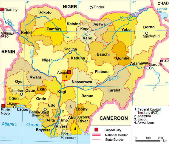
Map of Nigeria, showing state boundaries, cities, and waterways.

Nigeria map of Köppen climate classification.

The Zuma Rock near Suleja
Nigeria has a varied landscape. The far south is defined by its tropical rainforest climate, where annual rainfall is 60 to 80 inches (1,500 to 2,000 mm) a year.[92] In the southeast stands the Obudu Plateau. Coastal plains are found in both the southwest and the southeast.[93] This forest zone's most southerly portion is defined as "salt water swamp," also known as a mangrove swamp because of the large amount of mangroves in the area. North of this is fresh water swamp, containing different vegetation from the salt water swamp, and north of that is rain forest.[94][94]
Nigeria's most expansive topographical region is that of the valleys of the Niger and Benue river valleys (which merge into each other and form a "y" shape).[93] To the southwest of the Niger is "rugged" highland. To the southeast of the Benue are hills and mountains, which form the Mambilla Plateau, the highest plateau in Nigeria. This plateau extends through the border with Cameroon, where the montane land is part of the Bamenda Highlands of Cameroon.
The area near the border with Cameroon close to the coast is rich rainforest and part of the Cross-Sanaga-Bioko coastal forests ecoregion, an important centre for biodiversity. It is habitat for the drill monkey, which is found in the wild only in this area and across the border in Cameroon. The areas surrounding Calabar, Cross River State, also in this forest, are believed to contain the world's largest diversity of butterflies. The area of southern Nigeria between the Niger and the Cross Rivers has lost most of its forest because of development and harvesting by increased population, with it being replaced by grassland (see Cross-Niger transition forests).
Everything in between the far south and the far north is savannah (insignificant tree cover, with grasses and flowers located between trees). Rainfall is more limited, to between 500 and 1,500 millimetres (20 and 60 in) per year.[92] The savannah zone's three categories are Guinean forest-savanna mosaic, Sudan savannah, and Sahel savannah. Guinean forest-savanna mosaic is plains of tall grass interrupted by trees. Sudan savannah is similar but with shorter grasses and shorter trees. Sahel savannah consists of patches of grass and sand, found in the northeast.[94] In the Sahel region, rain is less than 500 millimetres (20 in) per year and the Sahara Desert is encroaching.[92] In the dry north-east corner of the country lies Lake Chad, which Nigeria shares with Niger, Chad and Cameroon.
Environmental issues
Main articles: Environmental issues in the Niger Delta and Deforestation in Nigeria
Nigeria's Delta region, home of the large oil industry, experiences serious oil spills and other environmental problems, which has caused conflict.Waste management including sewage treatment, the linked processes of deforestation and soil degradation, and climate change or global warming are the major environmental problems in Nigeria. Waste management presents problems in a mega city like Lagos and other major Nigerian cities which are linked with economic development, population growth and the inability of municipal councils to manage the resulting rise in industrial and domestic waste. This huge waste management problem is also attributable to unsustainable environmental management lifestyles of Kubwa Community in the Federal Capital Territory, where there are habits of indiscriminate disposal of waste, dumping of waste along or into the canals, sewerage systems that are channels for water flows, etc.
Haphazard industrial planning, increased urbanisation, poverty and lack of competence of the municipal government are seen as the major reasons for high levels of waste pollution in major Nigerian cities. Some of the 'solutions' have been disastrous to the environment, resulting in untreated waste being dumped in places where it can pollute waterways and groundwater.[95]
In 2005 Nigeria had the highest rate of deforestation in the world, according to the Food and Agriculture Organization of the United Nations (FAO).[96] In 2005 12.2%, the equivalent of 11,089,000 hectares had been forested in Nigeria. Between 1990 and 2000, Nigeria lost an average of 409,700 hectares of forest every year equal to an average annual deforestation rate of 2.38%. Between 1990 and 2005, in total Nigeria lost 35.7% of its forest cover, or around 6,145,000 hectares.[97]
In 2010, thousands of people were inadvertently exposed to lead containing soil / ore from informal gold mining with the northern state of Zamfara. While estimates vary, it is though that upwards of 400 children died of acute lead poisoning making this perhaps the largest lead poisoning fatality epidemic every encountered.[98] As of 2016, efforts to manage the exposure are ongoing.
Administrative divisions
Main article: Administrative divisions of Nigeria
| Major cities | |
| City | Population |
|---|---|
| Lagos | 8,048,430 |
| Kano | 2,828,861 |
| Ibadan | 2,559,853 |
| Benin City | 1,147,188 |
| Port Harcourt | 1,005,904 |
As of the 2006 census, Nigeria has eight cities with a population of over 1 million people (from largest to smallest: Lagos, Kano, Ibadan, Benin City and Port Harcourt. Lagos is the largest city in Africa, with a population of over 12 million in its urban area.[101]
A clickable map of Nigeria exhibiting its 36 states and the federal capital territory.

| States | ||
|---|---|---|
| Territory | ||

No comments:
Post a Comment